Daytona Beach, FL - Development chances for one disturbance increases. Now a new one has been spotted in the Central Atlantic.
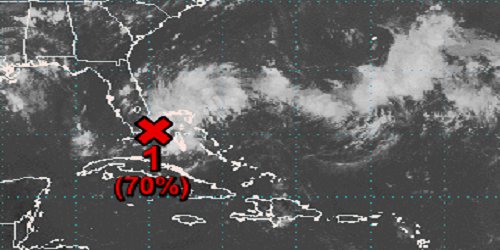
According to the National Hurricane Center, satellite and radar data shows that the tropical disturbance that's nearing the southeast coast of Florida is becoming more organized.
Right now the system is expected to move northwestward near or over the eastern part of the peninsula through tonight (August 23rd) and then move northward to northeastward over the Atlantic near the east coast of the central Florida peninsula tomorrow (August 24th).
After that, the system is expected to move northeast away from the southeast United States coast. The NHC says if the current trend continues, a tropical depression is likely to form by Saturday night.
Regardless of development, heavy rains are possible over the northwestern Bahamas and the southern and central Florida peninsula through the weekend.
An Air Force Reserve Hurricane Hunter aircraft is scheduled to investigate
the system on Saturday, if necessary.
Recent satellite wind data also indicates that a low pressure area has formed in association with a tropical wave located about 1300 miles east-southeast of the Windward Islands.
Additional development of this system is possible during the next few days, and a tropical depression could form late this weekend or early next week as it moves generally west to west-northwest.


