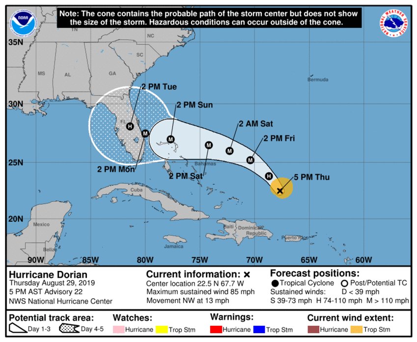
Daytona Beach, FL - The latest advisory from the National Hurricane Center shows a more westward turn by Friday, which could take aim at South Florida.
According to the NHC, Hurricane Dorian was last spotted around 400 miles east of the southeastern Bahamas. Dorian is still crawling northwest at 13 mph, with that motion expected to continue through Friday.
A west-northwestward to westward motion is forecast to begin by Friday night and continue into the weekend. On this track, Dorian should move over the Atlantic well east of the southeastern and central Bahamas tonight and on Friday, approach the northwestern Bahamas Saturday, and move near or over portions of the northwest Bahamas on Sunday.
Maximum sustained winds are still sitting around 85 mph with higher gusts. Strengthening is expected within the next few days, with Dorian expected to hit Category 3 strength by tomorrow afternoon and Category 4 strength by Sunday afternoon.
Hurricane-force winds extend outward up to 15 miles from the center and tropical-storm-force winds extend outward up to 90 miles.
Here are the #Dorian Key Messages for August 29, 5 pm EDT. Hurricane Watches could be issued for portions of the Bahamas tomorrow. More: https://t.co/tW4KeFW0gB pic.twitter.com/dBrrsYZAEU
— National Hurricane Center (@NHC_Atlantic) August 29, 2019
The new track shows that Dorian is expected to make a sharper turn west, which puts more of the Bahamas and parts of South Florida in the cone of uncertainty. As usual at this time of the track, a Florida impact is still unknown at this time, but local and state officials are urging residents to prepare and make their plans regardless.
News Daytona Beach will monitor the tropics and provide updates as soon as possible when they’re available.
Text STORM to 51879 for the latest reports regarding Hurricane Dorian.
You can download the free WNDB app for your Apple or Android device for updates regarding severe weather and tropical storms.
Listen live for updates on FM 93.5, AM 1150, WNDB and through our livesteam.


