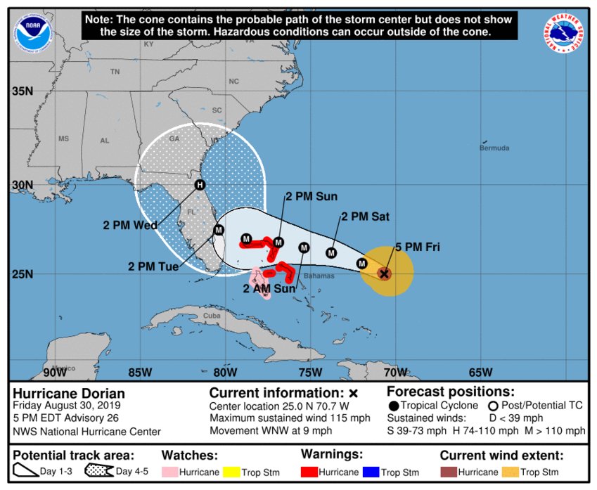
Daytona Beach, FL - The government of the Bahamas has put the Northwest Bahamas under a hurricane warning as the National Hurricane Center monitors the "well-defined" eye of Hurricane Dorian.
Dorian, which is still a few hundred miles away from the Bahamas, is still churning out maximum sustained winds around 115 mph as it moves towards the west-northwest near 9 mph.
A slower west-northwestward to westward motion should begin tonight and continue into early next week. On that track, the core of Dorian should move over the Atlantic north of the southeastern and central Bahamas tonight and tomorrow, be near or over the northwestern Bahamas on Sunday and be near the Florida east coast late Monday.
Models are also predicting a new type of landfall for Dorian, one that could hit somewhere in South Florida before moving up the east coast. However, it's still too early to tell as the tracks can change at any point.
5 PM EDT: Here are the latest Key Messages for #Dorian. For more information see https://t.co/tW4KeFW0gB pic.twitter.com/R97xO24eVt
— National Hurricane Center (@NHC_Atlantic) August 30, 2019
News Daytona Beach will monitor the tropics and provide updates as soon as possible when they’re available.
Text STORM to 51879 for the latest reports regarding Hurricane Dorian.
You can download the free WNDB app for your Apple or Android device for updates regarding severe weather and tropical storms.
Listen live for updates on FM 93.5, AM 1150, WNDB and through our livesteam.


