Daytona Beach, FL - The National Hurricane Center's newest advisory says conditions seem to be favoring the development of a stronger tropical disturbance.
As for what the disturbance could be - a depression or storm - they're not sure yet.
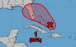
Satellite wind and surface observations show that a disturbance near the Bahamas has yet to develop closed circulation and that the winds are not strong as of yet.
However, surface pressures remain low and environmental conditions are favorable for a tropical depression or tropical storm to form within the next day or two as the system moves toward the northwest at 5 to 10 mph through the northwestern Bahamas and towards Florida.
The NHC also says that Potential Tropical Cyclone advisories could be needed sometime later today or tomorrow (September 13th) if the system were to develop faster.
Regardless of development, this disturbance will bring heavy rainfall and gusty winds to portions of the Bahamas through tomorrow, including areas of the northwestern Bahamas affected by Hurricane Dorian.
Florida could also see an influx of heavy rains and high winds as the system moves northwest towards the state. Interests within the state are urged to monitor the progress of the storm as it moves.
Forecasters also said that the system has a 70% chance of forming in the next 48 hours and 80% in the next five days.
News Daytona Beach will monitor the tropics and provide updates as soon as possible when they’re available.
You can download the free WNDB app for your Apple or Android device for updates regarding severe weather and tropical storms.
Listen live for updates on FM 93.5, AM 1150, WNDB and through our livesteam.


