Daytona Beach, FL - The National Hurricane Center announces that the 10th named storm of the 2019 Atlantic Hurricane Season has officially formed.
Tropical Storm Jerry, which was a tropical depression for a couple of days, was finally updated to its current status as of the 5 a.m. advisory from the NHC.
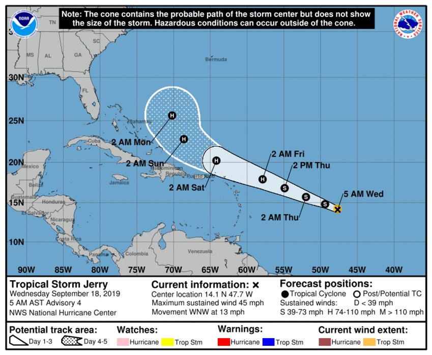
Right now, Jerry is around 960 miles east of the Leeward Islands as it moves to the west-northwest around 13 mph. A west-northwestward motion at a slightly faster forward speed is expected over the next few days.
Maximum sustained winds have hit 45 mph with higher gusts with tropical-storm-force winds extending outward up to 45 miles from the center. Further strengthening is forecast during the next couple of days, and Jerry is expected to become a hurricane by the time it reaches the northern Leeward Islands.
Here are the Latest Key Messages for recently upgraded Tropical Storm #Jerry (4 AM CDT Wednesday, September 18) More info: https://t.co/sYVOB3gkmI pic.twitter.com/qLObuP6XCB
— National Hurricane Center (@NHC_Atlantic) September 18, 2019
On the forecast track, the system will be near the northern Leeward Islands Thursday night (September 19th) or Friday (September 20th).
No Florida impact was predicted in the forecast track for Jerry. In fact, the current models seem to take Jerry north of the Leeward Islands before it makes a turn towards the north-northwest, running almost parallel to the Bahamas.
Regardless, the storm will be monitored and updates will be passed along if needed.
News Daytona Beach will monitor the tropics and provide updates as soon as possible when they’re available.
You can download the free WNDB app for your Apple or Android device for updates regarding severe weather and tropical storms.
Listen live for updates on FM 93.5, AM 1150, WNDB and through our livesteam.


