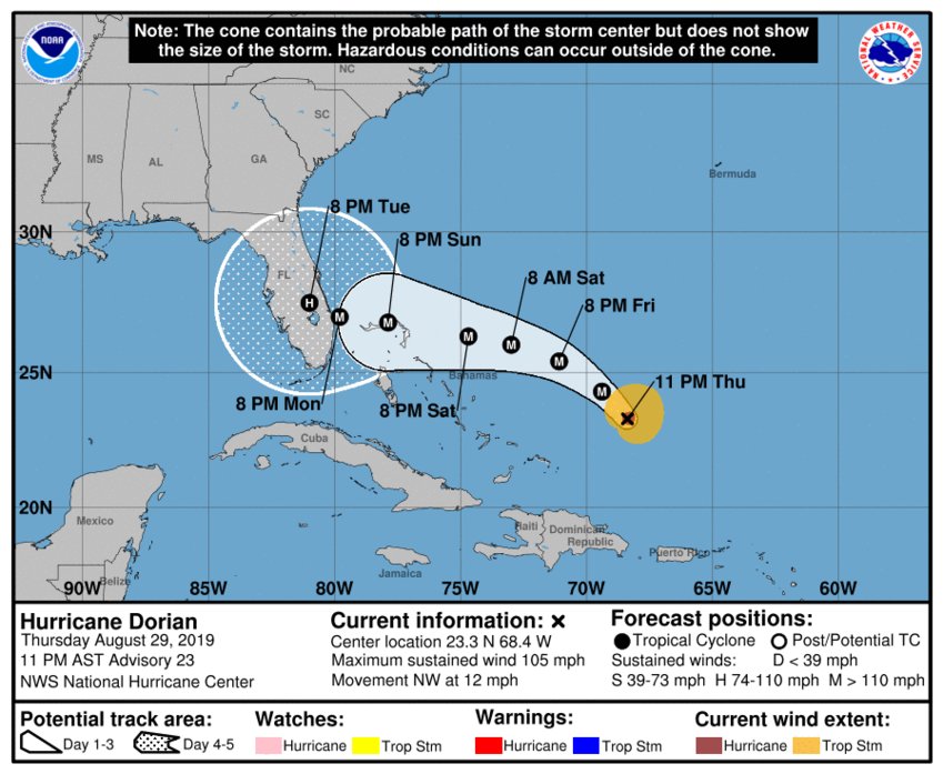
Daytona Beach, FL - The new advisory shows that Hurricane Dorian has made it to Category 2 strength while the forecast cone shifts farther to the south.
According to the National Hurricane Center's 11 p.m. advisory, Dorian is a few hundred miles away from the Bahamas over warm Atlantic waters, which is what helped boost the hurricane to a Category 2 status.
The advisory also shows that Dorian has since slowed since the last advisory (5 p.m. EST), dropping from 13 mph to 12 mph.
A west-northwestward to westward motion is forecast to begin by tomorrow night (August 30th) and continue into the weekend. On this track, Dorian should move over the Atlantic, east of the southeastern and central Bahamas tonight and tomorrow, approach the northwestern Bahamas Saturday (August 31st), and move near or over portions of the northwest Bahamas on Sunday (September 1st).
Maximum sustained winds have now increased to 105 mph with higher gusts. Dorian is expected to strengthen into a Category 3 then a Category 4 tomorrow and remain a major hurricane throughout the weekend.
Hurricane-force winds extend outward up to 25 miles from the center, and tropical-storm-force winds extend outward up to 105 miles.
One key fact to remember is to not pay attention to the center line of a forecast track, as a storm can be in any part of the cone of uncertainty. And while the track has shifted farther south, all of Florida is still within the forecast cone.
News Daytona Beach will monitor the tropics and provide updates as soon as possible when they’re available.
Text STORM to 51879 for the latest reports regarding Hurricane Dorian.
You can download the free WNDB app for your Apple or Android device for updates regarding severe weather and tropical storms.
Listen live for updates on FM 93.5, AM 1150, WNDB and through our livesteam.


