Daytona Beach, FL - Hurricane Dorian is getting stronger and it looks like the new forecast track has shifted farther south again.
Dorian, which was officially labeled a Category 2 during last night's 11 o'clock advisory, continues on its path through the Atlantic before it's expected to make a turn west towards the Bahamas and now what seems to be the southern part of the Florida peninsula.
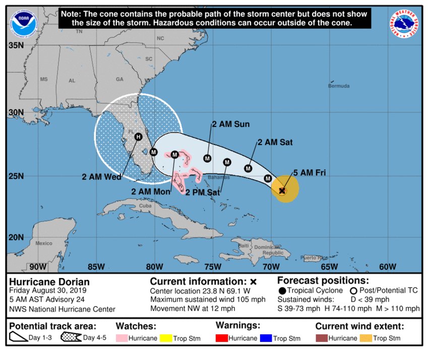
The National Hurricane Center says Dorian is still a few hundred miles away from the Bahamas, moving northwest at 12 mph. A slower west-northwestward to westward track is forecast to begin tonight and continue through the weekend.
With this track, the Bahamas can expect conditions to deteriorate as early as today and into the weekend as Dorian moves near or over parts of the islands.
Maximum sustained winds were recorded at 105 mph with higher gusts. Hurricane-force winds extend outward up to 25 miles from the center, and tropical-storm-force winds extend outward up to 105 miles.
Here are the 5 AM AST/EDT August 30 Key Messages for Hurricane #Dorian. A prolonged period of hazardous weather conditions that could last for a couple of days is possible across parts of Florida early next week. Visit https://t.co/tW4KeFW0gB for more info. pic.twitter.com/5n4nGwYNfB
— National Hurricane Center (@NHC_Atlantic) August 30, 2019
Hurricane watches are also in effect for parts of the Bahamas, as Dorian is expected within 48 hours.
And again, the forecast cone has shifted south but there is still a large margin of error this far out as to where the storm could actually lie within the cone. Dorian is expected to become a Category 3 this afternoon, then a Category 4 by early Sunday morning.
News Daytona Beach will monitor the tropics and provide updates as soon as possible when they’re available.
Text STORM to 51879 for the latest reports regarding Hurricane Dorian.
You can download the free WNDB app for your Apple or Android device for updates regarding severe weather and tropical storms.
Listen live for updates on FM 93.5, AM 1150, WNDB and through our livesteam.


