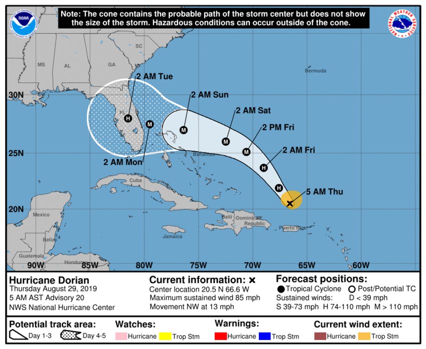
Daytona Beach, FL - Hurricane Dorian is still expected to hit Category 3 strength by this weekend, but there's still a wide range of possibilities on where Dorian could make landfall.
The National Hurricane Center says that Dorian is currently moving to the northwest near 13 mph, which is expected to continue into tomorrow (August 30th). Around that time, Dorian is expected to make a turn to the west towards the southeast United States and the east coast of Florida.
On this track, Dorian should move over the Atlantic well east of the southeastern and central Bahamas today and on Friday, and approach the northwestern Bahamas on Saturday (August 31st).
Here are the 5 AM AST/EDT August 29 Key Messages for Hurricane #Dorian. For more information, visit https://t.co/tW4KeFW0gB pic.twitter.com/IPNcswUGBt
— National Hurricane Center (@NHC_Atlantic) August 29, 2019
Maximum sustained winds are hovering around 85 mph with higher gusts, which leaves Dorian at a Category 1 for now. Hurricane-force winds extend outward up to 15 miles from the center, and tropical-storm-force winds extend outward up to 90 miles. By Friday, Dorian is expected to strengthen into a Category 3.
It's still uncertain as to where Hurricane Dorian will hit, seeing as the cone of uncertainty encompasses the entire length of the Florida peninsula. There's still some differing opinions when it comes to forecast models, but it seems a majority of models agree on a South Florida impact. But, any impact to Florida is still unknown.
What is known is that a high pressure system currently sitting in the Atlantic is what will help Dorian move west-northwest over the weekend and towards Florida and the southeast US.
News Daytona Beach will monitor the tropics and provide updates as soon as possible when they’re available.
Text STORM to 51879 for the latest reports regarding Hurricane Dorian.
You can download the free WNDB app for your Apple or Android device for updates regarding severe weather and tropical storms.
Listen live for updates on FM 93.5, AM 1150, WNDB and through our livesteam.


