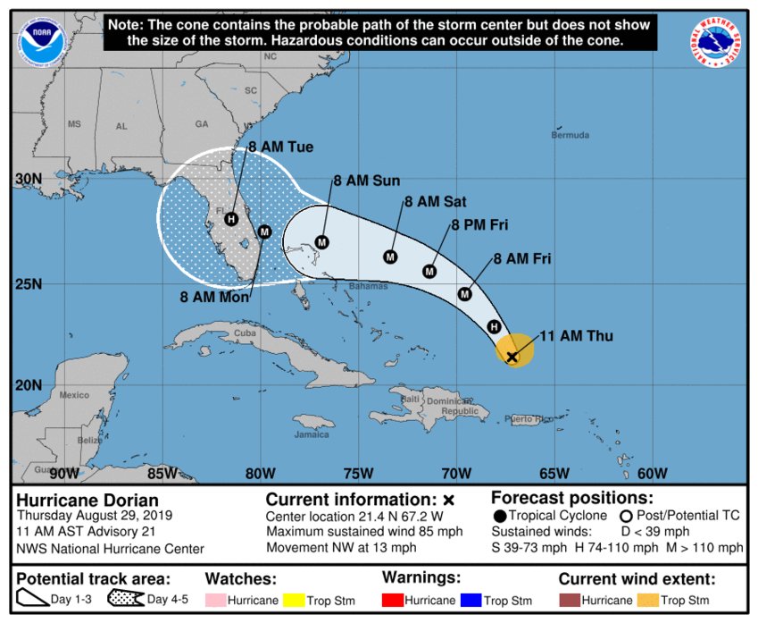
Daytona Beach, FL - As Hurricane Dorian heads out over open waters, forecasters are expecting the storm to strengthen close to a Category 4 by this weekend.
After skipping the 8 a.m. advisory during a Hurricane Hunter mission, the National Hurricane Center now says Dorian is moving northwest at 13 mph, and that track is still expected to continue until tomorrow (August 30th), where it's expected to turn.
Dorian should move over the Atlantic well east of the southeastern and central Bahamas today and on Friday, approach the northwestern Bahamas Saturday (August 31st), and move near or over portions of the northwest Bahamas on Sunday (September 1st).
Maximum sustained winds are still sitting around 85 mph with higher gusts close to 105 mph and the storm is still expected to reach Category 3 and 4 strength sometime this weekend.
The extent of a Florida impact is still unknown.
11 AM EDT: Here are the latest Key Messages on #Dorian https://t.co/tW4KeFW0gB pic.twitter.com/Go5d4kvSnk
— National Hurricane Center (@NHC_Atlantic) August 29, 2019
The NHC is urging residents to take action now and make the plans and preparations they need in place before Dorian approaches. You can click here for local information regarding sandbags and hurricane prep in Volusia and Flagler County.
News Daytona Beach will monitor the tropics and provide updates as soon as possible when they’re available.
Text STORM to 51879 for the latest reports regarding Hurricane Dorian.
You can download the free WNDB app for your Apple or Android device for updates regarding severe weather and tropical storms.
Listen live for updates on FM 93.5, AM 1150, WNDB and through our livesteam.


