
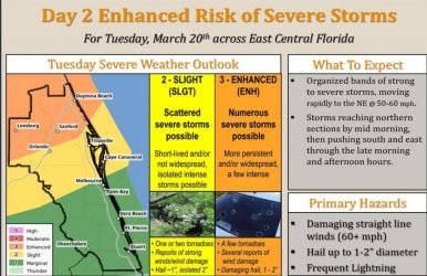
(Photo courtesy NWS)
"We are looking for that threat of severe storms with gusty winds, possible hail, and there is also the possibility of isolated tornadoes," Volkmer explains. The risk for storms will continue through Tuesday afternoon, and then storms should move east into the Atlantic Ocean by Tuesday evening. Temperatures in Volusia and Flagler Counties could reach into the lower 80's on Tuesday afternoon, and then temperatures are expected to cool down after the front moves through the area beginning Tuesday night. Wednesday high temperatures are expected to be in the upper 60's on Wednesday and the mid 60's on Thursday, according to Volkmer.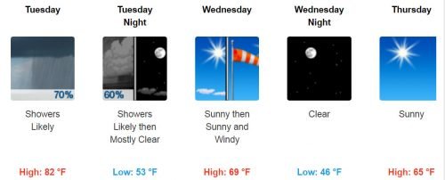
(Forecast for Daytona Beach courtesy NWS)
Residents can start preparing now for the potential storms. "The one thing people want to do is have a weather radio handy, or their smartphone, and pay attention to local media for any severe thunderstorm or tornado warnings," Volkmer says. "Then if a warning is issued, (residents should) immediately take shelter in a sturdy building and stay away from windows." Copyright Southern Stone Communications 2018.


